Increasing Solar Activity and the Effect on GNSS Positioning
Global Navigation Satellite Systems (GNSS) have revolutionised the way we navigate and locate ourselves on the surface of the Earth. However, GNSS signals are prone to interference and one of the most significant sources of interference is increased ionospheric activity.
Increased ionospheric activity is correlated with the following factors:
- Sunspot activity – increased ionospheric activity linked with the 11-year solar cycle.
- Solar and magnetic storms – cause an increase in the ionospheric activity.
- Geographic location – highest activity along the geomagnetic equator and in auroral (polar) regions.
- Seasonal variations – increased activity at the vernal and autumnal equinoxes.
- Diurnal (daily) variations – maximum effects normally experienced one hour after local sunset until midnight.
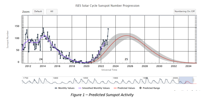
The solar cycle, also known as the solar magnetic activity cycle, sunspot cycle, or Schwabe cycle, is a nearly periodic 11-year change in the Sun’s activity measured in terms of variations in the number of observed sunspots on the Sun’s surface. Over the period of a solar cycle, levels of solar radiation and ejection of solar material, the number and size of sunspots, solar flares, and coronal loops all exhibit a synchronized fluctuation from a period of minimum activity to a period of a maximum activity back to a period of minimum activity. Below shows a graph of activity produced by the Space Weather Prediction Center (www.swpc.noaa.gov).
The current solar cycle 25 started in December 2019 and will continue to around 2030 with an expected peak in July 2025. This cycle is already showing signs of exceeding the predicted levels with significantly increased levels of solar activity escalating faster than expected.

Although there is no way to eliminate the effects of scintillation, the following steps may help mitigate the impact of scintillation:
- Use of multi-constellation, multi-frequency GNSS solutions to increase the number of observations available to the position solution (will help in the majority of situations but not all).
- Use of multi beam L-band (at least two independent downlink satellites) to ensure that corrections can still be received if lock to one satellite is lost.
- Selection and use of GNSS receivers and services from different service providers to benefit from any temporary improvement in performance associated with differences in hardware, firmware, or software.
- Use of GNSS+INS solutions to minimize any impact on position solution if satellite tracking impacted. However, these INS solutions are time dependant and will degrade until the DGNSS signal is restored.
Although these steps may mitigate the effects of scintillation, in some extreme circumstances all GNSS and L-band signals may be lost, resulting in total loss of GNSS positioning. The following steps are recommended:
- The impact of increased ionospheric activity and the potential to lose both stable satellite and L-band communications is taken into consideration during risk assessments when planning critical offshore activities.
- Selection and use of additional non-GNSS DP positioning reference systems to mitigate the potential for loss or instability of GNSS position during risk periods (e.g., integration of Inertial Navigation Systems (INS) or use of additional acoustic, optical, radar or other reference systems).
- Increased vigilance of DP operators for scintillation effects, especially after sunset.
If the vessel owner does not have these options, the operator should be cautious and make sure that the offshore management teams are aware of the potential for GNSS positioning disruption due to increased ionospheric activity and scintillation. To reduce the operational impact of these events, ASOG and CAM configurations should continue to be strictly adhered to in terms of diversity of position reference systems. The DP vessel and offshore crew must be prepared for GNSS failure. Something that occurred for several hours during the previous cycle in 2013-2014.
For more information, please contact [email protected]

IMCA Contact
Richard Purser
Technical Adviser - Marine
Contact
Information Note Details
Published date: 22 March 2023
Information note ID: 1634
Downloads
IMCA’s store terms and conditions (https://www.imca-int.com/legal-notices/terms/) apply to all downloads from IMCA’s website, including this document.
IMCA makes every effort to ensure the accuracy and reliability of the data contained in the documents it publishes, but IMCA shall not be liable for any guidance and/or recommendation and/or statement herein contained. The information contained in this document does not fulfil or replace any individual’s or Member's legal, regulatory or other duties or obligations in respect of their operations. Individuals and Members remain solely responsible for the safe, lawful and proper conduct of their operations.
